

Rain chances return Thursday, and we now have an ABC13 Weather Watch for Saturday
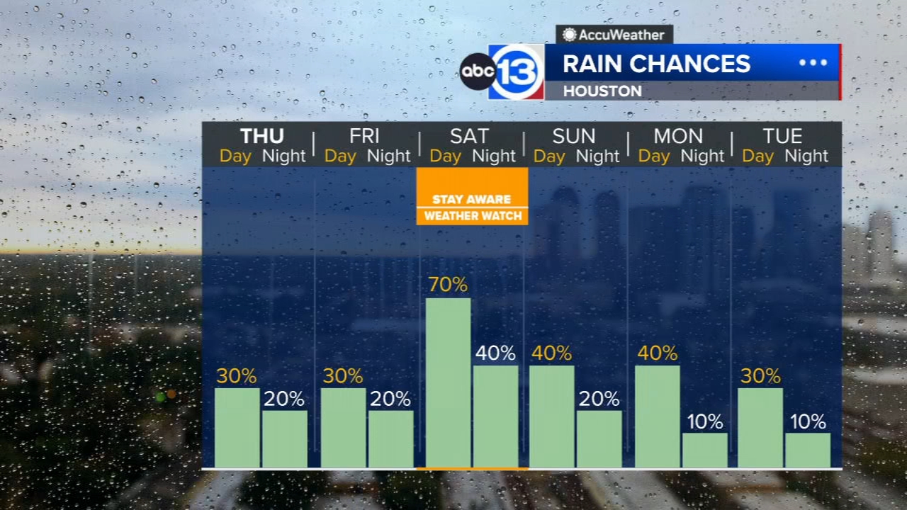
HOUSTON, Texas (KTRK) -- Rain chances will soon help ease our heat, but some storms Saturday could pack severe wind gusts. We've now declared an ABC13 Weather Watch for Saturday because of that potential for severe wind gusts when the storms arrive late Saturday.
While rain chances do return for Thursday and Friday, we are also still dealing with heat and ozone pollution. Ozone is a lung irritant that can trigger asthma attacks or a dry cough in sensitive individuals. It usually peaks between 3 p.m. and 7 p.m.
When ozone reaches "unhealthy" levels, the guidance from the EPA is as follows.
Sensitive groups: Do not do long or intense outdoor activities. Schedule outdoor activities in the morning when ozone is lower. Consider moving activities indoors. Sensitive groups include people
with lung disease such as asthma, older adults, children and teenagers, and people who are active outdoors.
People with asthma: Follow your asthma action plan and keep quick-relief medicine handy.
Everyone else: Reduce long or intense outdoor activity. Take more breaks, do less intense activities. Schedule outdoor activities in the morning when ozone is lower.
We will monitor the pollution sensors for you and keep you updated during our live TV newscasts today.
Overnight we'll have some clouds spread overhead from storms near the Texas-Louisiana border, and that will make it difficult for temperatures to drop much below 80 degrees. With higher levels of moisture in the atmosphere, rain chances will climb to 30% and the heat index will peak closer to 105. The actual air temp will peak just shy of 100. Any storm that pops up in the afternoon heat could pack strong wind gusts over 50 mph, and an isolated severe thunderstorm cannot be ruled out. Similar weather is expected Friday.
What should I know about Saturday's ABC13 Weather Watch?
Late Saturday we expect storm to erupt in the heat ahead of a weak summer front. The front will increase the coverage of storms higher than what we'll get Thursday or Friday, and because of the potential for severe wind gusts with these storms, we wanted to give you an early heads up to pay close attention to the weather during the late afternoon and evening. If you have outdoor plans, make sure you have a sturdy place you could seek shelter in should you cross paths with one of those strong or severe storms.
Are more storms possible on Sunday?
Yes, but they won't be as strong as what develops Sunday because the atmosphere will not get as hot. You chance of getting rain Sunday afternoon is at 40%.
What's happening in the tropics?
All is quiet in the Atlantic basin for now, but we are seeing signs it may come to life by mid August. Meanwhile, the Eastern Pacific remains very active. For a thorough update and in-depth video on what's happening in the tropics, head to our tropical update page.
13 ALERT RADAR MAPS:
Southeast Texas
Houston
Harris County
Galveston County
Montgomery/Walker/San Jacinto/Polk/Grimes Counties
Fort Bend/Wharton/Colorado Counties
Brazoria/Matagorda Counties
Have weather tips, videos, and photos?
Send it to ABC13 using the form below. If you have a video or photo to send, terms of use apply. If you don't, just hit 'skip upload' and send the details.